

NYZ080
Current watches, warnings, and advisories for Southwest Suffolk (NYZ080) NY
Coastal Flood Warning issued December 19 at 1:44AM EST until December 19 at 11:00AM EST by NWS Upton NY
* WHAT...
1 1/2 to 2 ft of inundation above ground level expectedin vulnerable areas near
the waterfront and shoreline.* WHERE...
Southwest Suffolk County.* WHEN...
From 6 AM to 11 AM EST this morning.* IMPACTS...
Widespread minor to moderate flooding of vulnerableareas near the waterfront and shoreline. Expect 1
1/2 to 2 ftof inundation above ground level in low lying, vulnerableareas. This will
result in numerous road closures and causewidespread flooding of low lying property including parkinglots,
parks, lawns and homes/businesses with basements nearthe waterfront. Vehicles parked in vulnerable areas near
thewaterfront will likely become flooded. Flooding will alsoextend inland from the waterfront along tidal
rivers and bays.* SHORELINE IMPACTS...
Breaking waves of 8 to 12 ft along theoceanfront during the time of high
tide will result inwidespread beach flooding and erosion, with scattered areas ofdune erosion. Wave
splashover is not likely.* ADDITIONAL DETAILS...
Heavy rain during the time of high tidemay exacerbate flood impacts. This forecast is
leaned towardsa higher end flood impact scenario, to account for slowertrend in cold frontal
passage and potential coincidence withheavy rain.
Coastal Flood Warning
Wind Advisory issued December 19 at 12:40AM EST until December 20 at 12:00AM EST by NWS Upton NY
* WHAT...
Southwest winds 20 to 30 mph with gusts up to 55 mphexpected. Isolated wind
gusts up to 60 mph are possible Fridaymorning.* WHERE...
Portions of southern Connecticut, northeast New Jersey,and southeast New York.* WHEN...
Until midnight EST tonight.* IMPACTS...
Gusty winds will blow around unsecured objects. Treelimbs could be blown down and a
few power outages may result.* ADDITIONAL DETAILS...
Winds will shift from southwest to westFriday afternoon.
Wind Advisory
****************
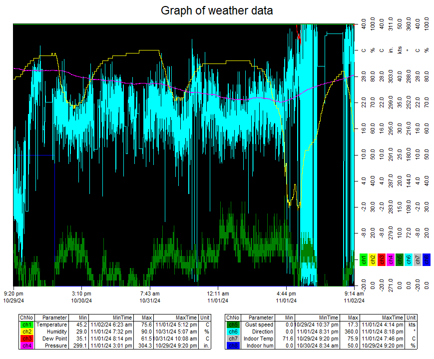
| Oak Neck Lane Weather | |||
|---|---|---|---|
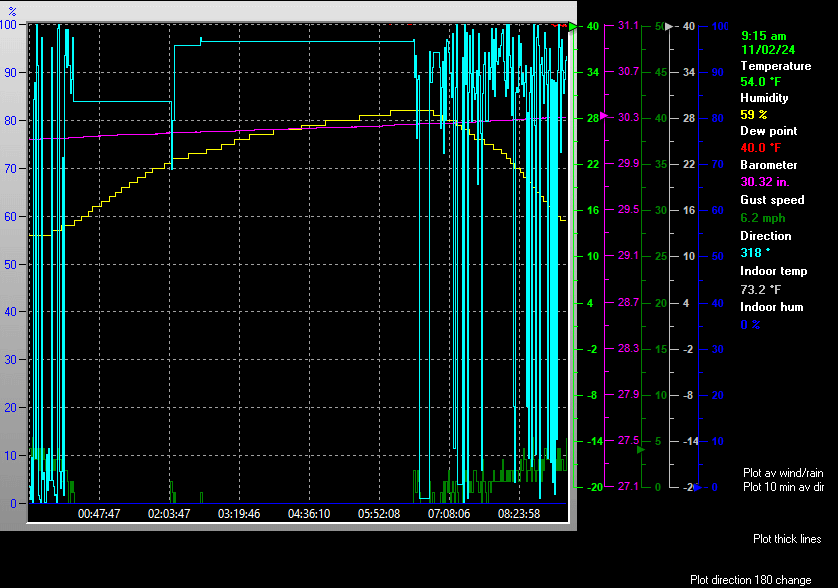
| LAST READING AT TIME: 10:00 AM DATE: December 19 2025, time of next update: 10:05 am | |||
| Current Weather | Dry | Current Temperature | 55.7°F (13.2°C), Apparent temp 42.8°F |
| Maximum Temperature (since midnight) | 56.1°F at: 9:58 AM | Minimum Temperature (since midnight) | 45.0°F at: 12:19 AM |
| Average windspeed (ten minute) | 25.0 mph | Wind Direction (ten minute) | S (180°) |
| Windchill Temperature | 55.7°F | Maximum Gust (last hour) | 44.9 mph at: 9:53 AM |
| Maximum Gust (since midnight) | 45.5 mph at: 9:49 AM | Maximum 1 minute average (since midnight) | 28.7 mph at: 9:53 AM |
| Rainfall (last hour) | 0.00 in. (0.0 mm) | Rainfall (since midnight) | 0.00 in. (0.0 mm) --- |
| Rainfall This month | 0.00 in. (0.0 mm) | Rainfall To date this year | 38.81 in. (985.8 mm) |
| Maximum rain per minute (last hour) | 0.00 in/min | Maximum rain per hour (last 6 hours) | 0.00 in/hour |
| Yesterdays rainfall | 0.00 in | DewPoint | 53.4°F (Wet Bulb :54.5°F ) |
| Humidity | 92 %, Humidex 59.7°F | Barometer corrected to msl | 29.368 in. (994.5 hPa) |
| Pressure change | -0.13 in. (last hour) | Trend (last hour) | FALLING |
| Pressure change (last 12 hours) | -0.79 in | Pressure change (last 6 hours) | -0.53 in |


Expires:202512191900;;840801
FPUS51 KOKX 190546
ZFPOKX

Zone Forecast Product
National Weather Service New York NY
1245 AM EST Fri Dec 19 2025


NYZ080-191900-
Southwest Suffolk-
1245 AM EST Fri Dec 19 2025

...WIND ADVISORY REMAINS IN EFFECT UNTIL MIDNIGHT EST TONIGHT...
...COASTAL FLOOD WARNING IN EFFECT FROM 6 AM TO 11 AM EST THIS
MORNING...

.TODAY...Showers with a slight chance of thunderstorms this
morning, then a chance of showers this afternoon. Very windy with
highs in the mid 50s. South winds 25 to 35 mph with gusts up to
55 mph, becoming southwest 20 to 30 mph with gusts up to 45 mph
this afternoon. Chance of rain near 100 percent.
.TONIGHT...Partly cloudy and very windy. Cooler with lows in the
mid 20s. West winds 25 to 35 mph with gusts up to 50 mph,
diminishing to 20 to 25 mph with gusts up to 40 mph after
midnight.
.SATURDAY...Mostly sunny. Highs in the lower 40s. West winds
15 to 20 mph. Gusts up to 30 mph in the morning.
.SATURDAY NIGHT...Mostly cloudy. Lows in the lower 30s. Southwest
winds 15 to 20 mph with gusts up to 30 mph.
.SUNDAY...Mostly sunny. Highs in the mid 40s. West winds 15 to
20 mph with gusts up to 30 mph.
.SUNDAY NIGHT...Partly cloudy in the evening, then becoming
mostly clear. Lows in the mid 20s.
.MONDAY...Sunny. Highs in the mid 30s.
.MONDAY NIGHT...Mostly cloudy. Lows in the mid 20s.
.TUESDAY...Rain and snow likely in the morning, then a chance of
rain in the afternoon. Highs in the lower 40s. Chance of
precipitation 60 percent.
.TUESDAY NIGHT...Mostly cloudy. Lows in the lower 30s.
.WEDNESDAY...Mostly sunny. Highs in the lower 40s.
.WEDNESDAY NIGHT...Partly cloudy in the evening, then becoming
mostly cloudy. Lows in the lower 30s.
.CHRISTMAS DAY...Partly sunny in the morning, then becoming
mostly cloudy. A 40 percent chance of rain. Highs in the upper
40s.

$$


NEW YORK CITY CENTRAL PARK, NY, United States (KNYC) 40-47N 073-58W 48M
Dec 19, 2025 - 09:28 AM EST / 2025.12.19 1428 UTC
Wind: from the SSE (160 degrees) at 9 MPH (8 KT) gusting to 33 MPH (29 KT) (direction variable):0
Visibility: 1 mile(s):0
Sky conditions: overcast
Weather: light rain; mist
Precipitation last hour: 0.23 inches
Temperature: 57.0 F (13.9 C)
Dew Point: 54.0 F (12.2 C)
Relative Humidity: 89%
Pressure (altimeter): 29.35 in. Hg (993 hPa)
ob: KNYC 191428Z AUTO 16008G29KT 080V200 1SM -RA BR OVC006 14/12 A2935 RMK AO2 PK WND 14029/1426 P0023 T01390122
cycle: 14
ISLIP LONG ISLAND MAC ART, NY, United States (KISP) 40-48N 073-06W 43M
Dec 19, 2025 - 09:03 AM EST / 2025.12.19 1403 UTC
Wind: from the SSE (150 degrees) at 21 MPH (18 KT) gusting to 33 MPH (29 KT):0
Visibility: 1 mile(s):0
Sky conditions: overcast
Weather: rain; mist
Precipitation last hour: 0.04 inches
Temperature: 55.9 F (13.3 C)
Dew Point: 53.1 F (11.7 C)
Relative Humidity: 90%
Pressure (altimeter): 29.46 in. Hg (997 hPa)
Pressure tendency: falling rapidly
ob: KISP 191403Z 15018G29KT 1SM R06/4000VP6000FT RA BR FEW008 BKN015 OVC055 13/12 A2946 RMK AO2 PK WND 16029/1400 SFC VIS 3 PRESFR P0004 T01330117
cycle: 14
Date: 12/19/2025
Sunrise at:
07:12 am

Sunset at:
04:28 pm

Moonrise at:
07:09 am 12/19/25

Moonset at:
03:45 pm 12/19/25

First Quarter  November 28 2025
Full moon  December 4 2025
Last QuarterDecember 11 2025
New moon December 20 2025
Moon age: 28 days,18 hours,11 minutes,1%
Hours of possible daylight today was 09:16:00
Use the RELOAD facility on your browser to retrieve the latest data.