Lab 5: Projections
1. Creating and reading the projection information
a. Coordinate system of a layer
ArcMap expects to find information on a layer's coordinate system in a
projection file (.prj). For example, when you ask it to open the shapefile
hydro.shp,
it looks for hydro.prj; if this file is not found, it issues a
warning,

and in the coordinate pane at the bottom of the window, the units of
the coordinates are "Unknown Units": 
The missing projection file can be created in ArcToolbox by clicking
Data Management Tools > Projections and Transformations > Define Projection,
then selecting from hundreds of standard projections built into the software.
The projection of our East Bay data set is found under Predefined > Projected
Coordinate Systems > State Plane > NAD 1927 > California Zone III. ArcToolbox
writes the .prj file, which includes
-
projection method, for example Lambert Conformal Conic
-
parameters of the projection, such as central meridian; standard parallels;
location of origin; units
-
geodetic model: datum and ellipsoid
After .prj files have been created for all the layers, ArcMap will no longer
give the warning when opening them, and the coordinate pane shows the correct
units:  .
You can see the layer's coordinate system in ArcMap in the Layer Properties
dialog box under the Source tab, or in ArcCatalog in the Metadata plane
under the Spatial tab. (Actually, ArcCatalog displays what it finds in
the layer's metadata file, which is written in XML. The metadata for the
shapefile hydro.shp is hydro.shp.xml. When you browse
a layer in ArcCatalog, it will create this metadata file if it doesn't
exist already, reading the .prj file to find the coordinate system.)
b. Coordinate system of a data frame
ArcMap assumes each data frame is using a common coordinate system for
all its layers. Normally, an empty frame takes on the coordinate system
of the first layer added to it. The frame's coordinate system is shown
in the Data Frame Properties dialog box on the Coordinate System tab, and
can also be set or reset there:
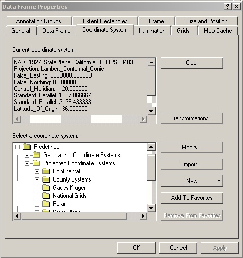
This dialog defines the coordinate system for the frame, not any particular
layer; that system is saved in the map document (.mxd), not in a projection
file associated with a layer. In fact, ArcMap will display the layers re-projected
on the fly into whatever system you select in the Data Frame Properties
dialog, using built-in functions to convert from the layer's own coordinates.
The coordinates written in the shapefile don't change, but ArcMap computes
new coordinates for display. For example, here's the same shapefile displayed
in two data frames with different coordinate systems:

The frame on the left is in geographic coordinates, GCS_North_American_1983,
the frame on the right is in a projected coordinate system, North_America_Albers_Equal_Area_Conic.
A layer may be exported with its data frame's projection: this means
ArcMap writes a new copy of all the layer files and also writes a .prj
file containing the data frame's projection, even if the original layer
didn't have a .prj file.
2. Changing the projection of a layer
Let's see what happens when we change a layer's projection. First, look
at the vegetation layer with ArcCatalog to check that it is in the State
Plane projection.
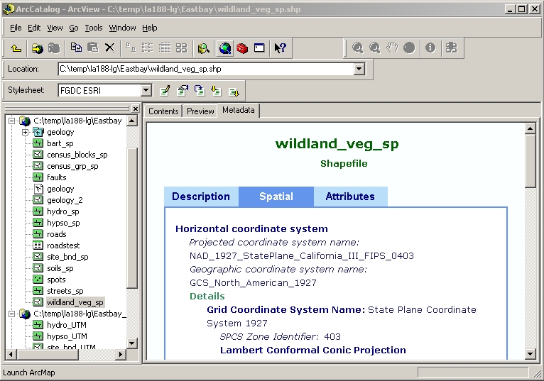
ArcToolbox can re-project a layer, which means inverting the projection
to get geographical coordinates (latitude and longitude); computing new
projected coordinates using a different projection; and writing the new
coordinates in a new shapefile. Let's re-project this layer into Universal
Transverse Mercator Zone 10. Note that both projections use geographical
coordinates referred to the North American Datum of 1927.
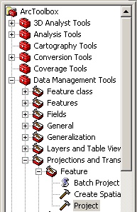
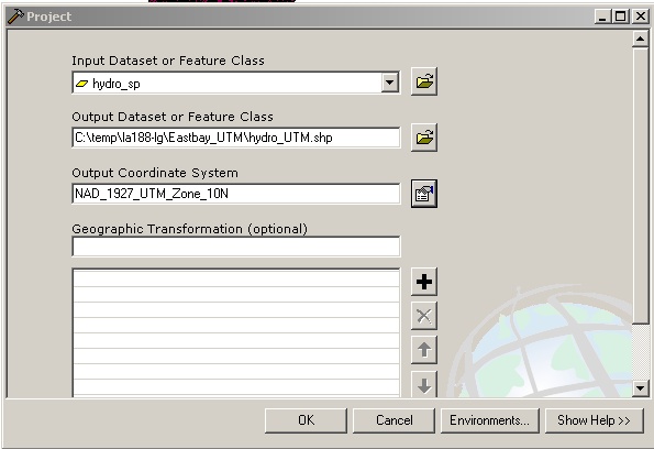
(The first time I tried to re-project a layer that was currently open
in ArcMap, ArcToolbox responded with a totally uninformative error message.
I quit the program, tried again, and then it worked fine.) Compare the
original shapefile:
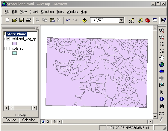
to the re-projected one:
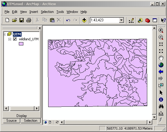
(I opened it in a different instance of ArcMap. If I had opened the
re-projected layer in the same data frame with the original, it would have
automatically been projected back into the frame's coordinate system, and
looked exactly the same as before!)
The re-projected layer is tilted slightly differently because a different
projection means a different choice of which meridians appear as vertical
lines on the map. Also, the coordinates are different, not just because
they're in meters instead of feet, but also because of a different choice
of coordinate origin. We can find out the coordinate origin by looking
at the metadata for the new layer:
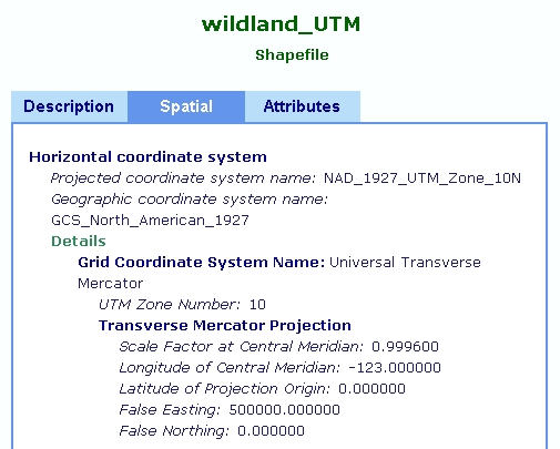
In the UTM system the latitude of projection origin is 0 degrees (the
equator), and the false northing is 0, so the equator has a y coordinate
of 0 meters. The y coordinate of our data set (see the coordinates in the
ArcMap screen capture) is about 4 million meters: that's how far north
of the equator it is.
3. Transformation to a new geographic coordinate system
Finally, ArcToolbox can also transform coordinates from one geographic
coordinate system to another. Each coordinate system has an associated
ellipsoid model of the Earth, which can change when ellipsoids are chosen
to best fit different regions of the Earth as well as when the accuracy
of measurements is improved. Here's how the ellipsoids used in the North
American Datums of 1927 and 1983 compare:
Also, the latitude and longitude of the same point on the Earth's surface
is different in NAD83 from NAD27. These coordinates were calculated by
minimizing errors over the whole survey network, and from 1927 to 1983
more survey points were added and accuracy was improved, so the best estimate
of the correct latitude and longitude of a particular point has changed.
The National Geodetic Survey developed software to do this conversion,
called NADCON, and it is incorporated into ArcToolbox.

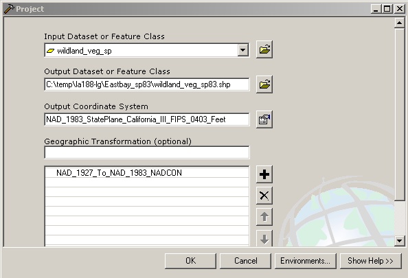
ArcToolbox back-projects from the State Plane to geographic coordinates;
transforms the geographic coordinates; re-projects them into another State
Plane; and writes the new coordinates in a new shapefile.
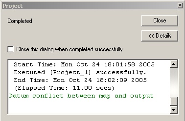
Then the layer appears in ArcMap, but caution: if you try to display
a NAD83 based shapefile in the same data frame with a NAD27 one, ArcToolbox
issues a warning, "Datum conflict between map and output".
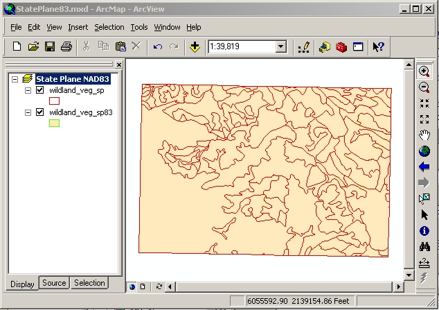
Even so, there's no visible difference when the two layers are displayed
on top of each other:
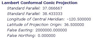
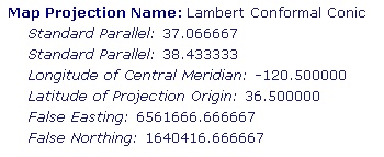
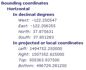
However, the coordinates have changed. Most of the change is because
a different "false easting" and "false northing" are applied in the 1983-based
State Plane projection. But also, the geographic coordinates have changed
just a little bit: about .001 degree longitude and .0001 degree latitude.
| |
NAD 1927
|
NAD 1983
|
| Origin of coordinates |
 |
 |
| Position of our data set |
 |
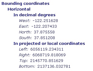 |
The change in latitude and longitude is enough to change the projected
coordinates by about 300 feet to the west and 10 feet to the south on top
of the change in origin. This agrees with the map of latitude
and longitude
datum shifts associated with the conversion. (Actually, NADCON looks
up the shifts on a grid of size 15 minutes (0.25 degree), which is larger
than the area shown in our map. Our whole map likely lies within one NADCON
grid, so the same correction was applied to every point on the map, and
that's why it doesn't look any different.) Here's how I calculated the
datum shifts:
|
original coord |
remove old origin |
add new origin |
expected position |
actual-expected |
| left |
1494752.25 |
-2000000 |
+6561666.667 |
6056418.917 |
-299.683 |
| bottom |
505363.9375 |
-0 |
+1640416.667 |
2145780.605 |
-9.754 |
New position of left bounding coordinate due to change in "false easting"
alone would be 6056418.917 feet. The actual coordinate is less (i.e., west)
than this by about 300 feet due to change in the best estimate of longitude.
Likewise for the bottom coordinate.


